If you enjoy ungroomed cross country skiing, the Pagosa area abounds!
Dogs should be leashed or under voice control. Wildlife is a common site in these more remote areas. Winter is hard, please don't let your pet make it even harder. Pick up waste or bury it off common ski areas!
All skiers, especially those who choose to go off the road route, need to have navigation skills and backcountry/avalanche gear. Always let someone know where you are going and when to expect you back.
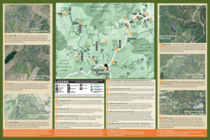
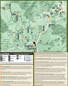
Full PNC Trail Maps
Ungroomed Trail Systems near the Town of Pagosa Springs
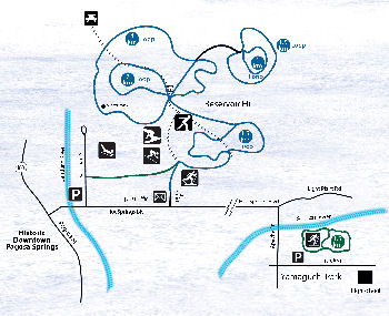
Reservoir Hill
Reservoir Hill is located in the heart of downtown Pagosa Springs and the trailhead is within easy walking distance of a variety of downtown lodging establishments and public parking. It provides beautiful views of the surrounding mountains and downtown.
This location is open to all non-motorized winter activities. Recommended for intermediate skiers due to slope and need for speed control. A few of the trails get packed by snowshoers, bikers and walkers.
Getting there: Take U.S. 160 to downtown Pagosa Springs. Turn south at the Hot Springs Boulevard traffic light and take the second left onto San Juan Street. Look for a public parking area on the left. From the public parking area, it is a short uphill walk to the Spa Trailhead, which provides access to Reservoir Hill.
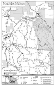
Turkey Springs Trails System and Roads
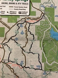
Turkey Springs trail system provides miles and miles of ungroomed skiing in rolling meadows and Ponderosa pine forest. Turkey Springs and Gate 5 trailheads are popular areas where skiers, snowshoers and walkers often pack trail.
The DUST2 Wheel Club frequently grooms two trail loops leaving from the main Turkey Springs trailhead and totaling 14 miles for fat bikes. While cross country skiing is permitted on this trail, it is narrow which makes skate skiing difficult. Please be respectful and step to the side to allow fat bikes to pass as this is their designated groomed trail.
Click for more information.
Grooming of the roads and ATV trails within the Turkey Springs Trail System is occasionally done by the Trail Blazers Snowmobile Club.
Click for more information.
Getting there: Drive 6.3 miles north of U.S. 160 on Piedra Road (County Road 600). The trailhead is on the left, immediately after the cattle guard. Please park in the parking lot if it is plowed.
Full Turkey Springs Trail System
Trails groomed for Fat Biking (In black)
Additional National Forest Options
Note that all routes on Forest Service roads are generally gradual uphill ascents with downhill slopes on the return. Beginners should be aware of the required ability to control speed on these routes. All skiers, especially those who choose to go off the road route, need to have navigation skills and backcountry/avalanche gear. Always let someone know where you are going and when to expect you back.
Ungroomed Nordic Ski Options East on U.S. 160:
East Fork Road(Forest Road 667)
This multi-use trail is an enjoyable route for one or several miles. It parallels the East Fork of the San Juan River. It is eight miles to the historic Silver Falls Guard Station. Please stay on the road as it passes through private property.
This area sees significant snowmobile use. It is groomed occasionally by the Wolf Creek Trail Blazers snowmobile club which, when groomed, can provide a quality distance ski.
Getting there: Travel 9.5 miles east on U.S. 160, turn southeast (right) on East Fork Road, then continue about 3/4 mile to the parking area at the end of the plowed road.
Jackson Mountain Road (Forest Road 037)
This multi-use trail is a gradual, uphill, four-mile route to the end of an unplowed road with additional opportunities to travel other roads in the area. Jackson Mountain is a popular area for snowmobiles.
Getting there: Travel 7.3 miles northeast on U.S. 160. Parking is on the left at Jackson Mountain Road.
Lobo Overlook (Forest Road 402)
This multi-use trail climbs generally uphill for 1.5 miles to the Lobo Overlook and the Continental Divide Trail (and the microwave tower). Skiers will be rewarded with breathtaking views at the top. Snowmobiles are allowed on the forest service road and provide a packed trail for the ascent.
Getting there: Travel 23.2 miles northeast on U.S. 160. Parking and the road to the overlook are north of the highway just past the Continental Divide sign at Wolf Creek Pass.
Wolf Creek Road (on Wolf Creek Pass - Forest Road 725)
This multi-use trail has three forest access points along approximately three miles of road with some fairly open, moderate terrain in this area. Views are spectacular. This area is popular for snowmobiling. Skiers typically use Lobo Overlook, 1/2 mile east of the Wolf Creek Pass summit, on the north side of the road.
Getting there: Travel 20 miles northeast on U.S. 160 to Wolf Creek Road (725).
Ungroomed Nordic Ski Options South on U.S. 84:
Blanco River Road (Forest Road 656)
Blanco River Road is closed at the highway. This multi-use trail generally parallels the river for 2.5 miles from the highway to Blanco River campground.
Getting there: Travel 11 miles south on U.S. 84 to Blanco River Road. Parking may be limited.
Kenney Flats Road (Forest Road 006)
This multi-use road through open, fairly level terrain is good for beginners and provides several possible routes.
Getting there: Travel 14 miles south on U.S. 84 to Kenney Flats Road. Parking is located on the east (left) side of the highway.
Nipple Mountain Road (Forest Road 665)
In addition to traveling Nipple Mountain Road, there are a few other options in this area. The hardy person with a map and backcountry skills may identify lengthy or loop trips.
Getting there: From downtown, go east on U.S. 160 to the junction with U.S. 84. Travel 1/8 mile south on U.S. 84 and turn left on Mill Creek Road (CR 302), drive approximately 5 miles to trailhead parking before the junction with Nipple Mountain Road (665).
Ungroomed Nordic Ski Options North of Pagosa Springs:
Fourmile Road (645) and Plumtaw Road (634)
The first 1.5 miles of this route is uphill. At the junction, one can continue on Fourmile Road or go left on Plumtaw Road. For a long trek, continue on Plumtaw Road to its junction with McManus Road in the Upper Piedra, a distance of about 17 miles.
This multi-use trail is groomed occasionally by the Wolf Creek Trailblazers snowmobile club. When groomed, it can provide a quality distance ski.
Getting there: Turn east on Lewis Street, immediate north (left) on Fifth Street, which becomes Fourmile Road. Travel 6.5 miles north on Fourmile Road to the closure point near the national forest boundary.
Williams Creek Reservoir Area
This multi-use area is open, fairly flat area that is good for beginners. Enjoy spectacular views of mountains and large, open parks. Unplowed road continues past Williams Creek Reservoir to Poison Park and Williams Creek trails.
Once the ice becomes solid, the actual reservoir provides a really unique experience for skiing! The distance around the entire lake edge is approximately 3km.
Please note, the road to the Reservoir may take a few days to be plowed after storms.
Getting there: From downtown, travel two miles west on U.S. 160, turn north on Piedra Road (630 then 631). Travel 22 miles, and then turn right on Williams Creek Road (640), continue to Williams Creek Reservoir.


